 |
| A place for contemplation |
We’d hiked the Grand Canyon, and marveled. We’d clamored over Zion’s red sandstone, and
were amazed (and scared). What could
beat that?
 |
| Fascinated by Fairyland |
Hoodoos. Hoodoos
could beat that.
 |
| What are hoodoos, and where did they come from? |
We drove into Bryce Canyon as it was beginning to snow. SNOW???
We’d just been slathering on sunscreen so as not to burn up. But Bryce Canyon (not really a canyon, but a
cliff structure known as an amphitheater) is another 3000 feet above Zion’s
river basin, and suddenly it was cold again at 7700 feet of altitude.
 |
| Window arch to the Escalante Grand Staircase |
 |
| Dramatic formations |
We got there in the evening, with the snow sputtering on and
off. We had just enough light to walk
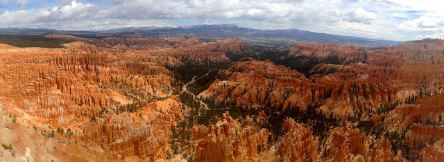
from Sunset to Sunrise point—and there were the hoodoos. Thousands of them, all silently looking down
into the canyon, in pinks and reds and beiges, a whole city of them.
 |
| Hoodoo city |
The Paiute legend says that there was a city here once. The people started behaving badly, and Coyote
was very unhappy. To teach them a
lesson, he changed them all to stone, whatever they were doing—walking, standing,
talking, sitting. The stone city
remains.
 |
| Hoodoos as far as the eye can see |
Hoodoo is a perfect name for these rock formations. The origin of the name varies, but most agree
that it comes from a word that means something like “scary.” And they are certainly mysterious, their forms
appearing around the bends of trails winding through the various amphitheaters
of this ancient fault-and cliff-line.
 |
| Hoodoos watching over you |
A hoodoo is a spire or pinnacle that is topped by a harder
stone. Formed not from water erosion but
more a combination of freezing and thawing, the softer stone underneath the
capstone layer cracks and layers, first into fins, then hoodoos, then spires,
and finally succumbing to complete collapse.
 |
| Hoodoos before a storm |
The landscape is quite active; every year some hoodoos
collapse, and others are formed, in the thousands that lurk in these magical
places.
 |
| Hoodoos on the upslope |
With rain threatening to pour down out of a dark sky, my
family turned back to the RV, while I continued on a trail through a part of
the hoodoos dubbed “Fairyland.”
 |
| Splitting up--they turned back, I went on the 6-mile hike |
The magic is impossible to capture in pictures, although I
tried. I stopped and gaped around just
about every turn at the impossibly beautiful colors and formations. The sky blackened and threatened to destroy
my iPhone, but the rain held off until I pulled into the RV campground on my
bike.
 |
| The winding Fairyland trail |
The next day we drove to Rainbow Point, where we walked
through lingering snow to see the 1500-year-old Bristlecone pines. It snowed through the sunshine
intermittently, and the 9000-foot elevation felt brisk. I was sorry we didn’t have time to walk the
Under The Rim trail to see the hoodoos from a different vantage point. But—the leitmotif of our trip—we had to move
on.
 |
| A Bristlecone Pine barely hangs on--for centuries! |
 |
| The amphitheater is full of stone people |
On our way north to Arches and Canyonlands we drove through
Capitol Reef National Park, a beautiful 100-mile-long waterpocket fold whose
name derives from a huge sandstone formation resembling the nation’s capitol
building, and the “reefs” or barriers encountered by early settlers which were
created by this split-valley formation.
 |
| It sorta does look like the Capitol Building, in a sandstone kind of way |
 |
| Driving into the campground, only to find no vacancy |
We again didn’t have enough time to enjoy the beautiful
fruit orchards and cottonwood shade of the valley settled by Mormon
homesteaders of early last century, and we drove past the huge formations,
auto-touring the park. We had to move
on. The last two big parks, Arches and
Canyonlands, were calling to us.
 |
| Bye bye, Capitol Reef We'll have to plan better next time! |


Ha, I finally found your blog! These pictures are gorgeous, who took them?
ReplyDelete